
 Eesti
Eesti Русский
 Suomi
SuomiNo products in the cart.

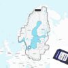
Garmin Gulf of Finland & Riga – Marine Charts
€258.00
Garmin Navionics+™ NSEU050R marine charts for Gulf of Finland and Gulf of Riga. Detailed coastal and inland mapping with Auto Guidance+ routing, depth shading and daily updates via a one-year subscription. Delivered on microSD™/SD™ card for Garmin chartplotters.
Garmin Navionics+™ Marine Charts – Gulf of Finland & Riga (NSEU050R)
Garmin Navionics+™ cartography provides detailed, easy-to-read marine charts for the Gulf of Finland and Gulf of Riga, combining trusted Garmin and Navionics mapping data in one solution. Designed for Garmin chartplotters, these charts offer vibrant colours, clear contours and powerful navigation tools for safer and more efficient boating and fishing.
Plan routes with confidence using built-in Auto Guidance+™ technology, customise your view with multiple chart layers and overlays, and keep your maps up to date with daily chart updates through the ActiveCaptain® app. High-resolution depth contours and shading help you quickly identify fishing areas, shallow water and bottom structure.
Key Features
- Detailed coastal and inland lake coverage
- Auto Guidance+™ dock-to-dock routing suggestions
- Daily chart updates with 1-year subscription
- Up to 0.5 m depth contours for precise navigation
- Depth range shading and shallow water shading
- Community points of interest via ActiveCaptain®
- Compatible with Garmin chartplotters (microSD™/SD™)
Specifications
| Coverage Area | Gulf of Finland & Gulf of Riga |
| Product Code | NSEU050R |
| Format | microSD™ / SD™ card |
| Compatibility | Garmin chartplotters |
| Updates | Daily via ActiveCaptain® app |
| Subscription | 1 year included |
| Contours | Up to 0.5 m |
| Routing | Auto Guidance+™ |